Sunday, May 15, 2011

More high water

Since last post the lake got yet higher, but on this day was back to about the same.

It was starting to rain (and forecast through next Wednesday) as we launched from Converse Bay and headed south.  Destination Lewis Creek.

A friend had told me she has to wade or row to get from her house on Long Point so I wanted to take a look.  The camera's battery was pretty low, so it died early on, but there are a few pics.

This no-parking zone is on the main drag for the point

From Kayak2011


Paddling down South Road.  You can see the high water mark on the white house.


Oh, last Wednesday evening a couple of us went out on Shelburne Bay.  Saw only one or 2 houses flooded, and one successful defense.  This dike is new.  It was put in to protect the road in front of this house.  Working so far..

Monday, May 02, 2011

More flooded

Since last week's trip onto flooded Lake Champlain, the water has risen another couple of feet to a record high of 102.8 feet.

At the Converse Bay boat ramp there was a guy getting his truck lined up to haul a  boat out who repeatedly warned us how cold the water was and how rough with 5 foot rollers once you got out of the bay and we shouldn't go out in (mere) kayaks.  When it was clear we were still planning to go he was overheard remarking to his mate about bleeping idiots.  My own reaction was that all the cold water deaths in the news this year have been people either in motor boats or whose truck accidentally went in the lake.

When we cleared the point and entered the main lake, we didn't see much of any waves over 1 foot, mostly less.
Lots of floody stuff though, like plumes of brown water from mud that eroded off softer bluffs normally above the water line.

The Charlotte-Essex ferry is closed.  A good idea with the state of the loading area:

From Kayak2011


There were lots of flooded boat houses, and docks under water.


We lunched at Shelburne town beach (what beach?) then headed out into the lake for a straight downwind shot back in the "5 foot rollers" rather than following the shore.

Monday, April 25, 2011

Winooski F&W


"Launching at 2 pm from WInooski F&W in Colchester, then heading out to the lake.
It's a raw, wet, and windy day."  (water 34 degrees, air mid 30's, 30+ knot wind, and sleet/rain at time of posting) 

By trip time the precipitation had stopped, air temp was up to 40, but the wind was holding up.

The Winooski boat ramp is far enough up river that it's sheltered from the lake, so launching was calm and easy. The lake level is high enough, just a hair under 101 feet, that we didn't have to paddle around that last bend to get to the lake. It was possible to just paddle through the woods.
Image

When we got in sight of the river mouth, the wind was howling pretty loudly, and we could see breaking surf in the distance. 
Image
Once out in the lake we headed upwind (south). It was one of those days where you spend a lot of time looking up at the waves coming at you.  Effort needed to progress was not sprint, but enough that the big enchilada I had for lunch was complaining about getting squeezed.  

Eventually we got to some point that had pretty good clapotis (reflecting waves) on the south side.  After running that we headed back out into the lake enough to get a straight downwind run to the bridge.  

The bridge was in the sheltered area, but the waves still had enough momentum to give us a little kick going under.

Monday, April 18, 2011

Springtime

Springtime?  On Saturday the water was 35, the air a little warmer, a good wind predicted,  and the lake is officially in flood.  But... there were 2 separate kayak trips.  I opted for North Hero in the morning as I had a commitment later in the day plus rain was more likely in the afternoon.

The beach we'd normally launch from is under several feet of water so we're starting from a steep shoreline with good size waves coming directly onshore.

The procedure (so I'm told) is wait for a relative lull, go out a few steps, jump in the boat with one foot (the other hanging), paddle like mad to get past the clapotis, then put other foot in, skirt up, and pump out whatever waves washed in during the process.  Pump goes in the cockpit because the waves could tear it out of the bungies.

Real world:
1) Figure out that for me there's no "quick jump" into the borrowed CD Rumor as it's more of a "gradually wriggle in" fit.  Go back and get a wider boat.

2) Do the jump in and paddle thing.  The put-other-foot-in step is interrupted by not being able to get said foot past the pump in the cockpit. Big wave comes during this and everything goes over.

3) Put pump in the bungies, get back in the capsized kayak and roll up, attach skirt, and pump.

Phelps, who had no pump, managed to get his 2nd foot in first try.

At least now I can say I've done self rescue "in conditions" (wind, waves, near freezing water.)  Though I've been knocked down before while entering/exiting, it's always been where I could stand, and in deeper water I've always been in the kayak so it was just a matter of rolling up.

After that things went pretty smoothly.  Paddled out along the Colchester causeway which gave us shelter from wind and waves.  At the cut we went to the other side and confirmed that it was rougher over there, then back to the lee.  For the return, we  peeled away from the causeway and rode the wind back to the start.


I heard the other trip launched in a sheltered bay,  so didn't hit the waves right away.

Tuesday, March 15, 2011

Maple has terroir! Who knew?

From Vermont Public Radio:
"Henry Marckres is the maple specialist for the Vermont Department of Agriculture. He's tasted maple syrup almost every day for nearly 3 decades! He's judged contests around the country, sampled batches from sugarmakers from Highgate to Bennington, and he's the arbiter of quality for the state of Vermont.
He spent some time with VPR's Jane Lindholm and shared his thoughts on what distinguishes one jar of maple syrup from another."


Audio interview:
http://www.vpr.net/news_detail/90310/

I must say I can't tell a Putney from a Shelburne.

In some ways syrup in Vermont is like moonshine in the south.  It's made in the woods, lots of boiling and steam involved.  Stores carry it, but many people just get it "from a guy."  Maybe a guy at work from the trunk of his car in the parking lot, or trek out to a sugar shack.  I usually get it from my barber.  My last fix came from a friend packed in a 5 pound sour cream container.

Thursday, February 10, 2011

More snow

I think I've had to shovel snow every day in the last week except Saturday.  Saturday was a technicality.

I had tickets for the Academy of St. Martin in the Fields chamber ensemble in Rutland (about 70 miles south on Rt 7.)

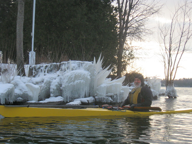
Kayak buddy Sam lives pretty close to Rutland.  He switches over to back country skiing once the snow builds up and is always trying to get me to come down there, so I called and made arrangements.   He suggested that I probably couldn't get to his house without 4 wheel drive, so meet him at the local store.


We took off through the forest from his house, skirting the Mountain Top Inn, picking up a mile or 2 of the Catamount Trail (a ski trail that spans Vermont from north to south,) and hitting the Chittenden reservoir.

From Other2011

The tiny black dot on the snow in the distance is somebody ice fishing.


On the way back it started snowing hard enough to remind me why I started wearing contact lenses for winter sports (but not today!)

After getting back, Sam drove me back to my car.  Scraped the windows off and headed to Rutland, where there's a covered parking garage across the street from the theater (yay).

The box office was holding my tickets.. in theory.... After flipping through a box of envelopes they can't find them.
"Did you order them online?"
"No.  XXXX from VPR (Vermont Public Radio) called it in. "

They check the box of envelopes again, look over some lists, then "Hmmmm.. I don't see it anywhere."

Sinking feeling.....

"Don't worry, we'll get you in."

Yes, it's Vermont!  On the strength of showing up and saying I'm supposed to have a ticket, they trust.

"Robin isn't coming, Here's her ticket."

Center seat, fourth row.  Cool!

Usually at things like this you see people you know, but since I'm not from around there, no (though I *do* know Robin, whose seat I'm in.)
The topics of pre-concert small talk were road conditions and preparation for sugaring season.  Since I drove a ways and tap my one maple tree I guess I fit in.

The concert was great, followed by a performer meet & greet in the lobby over cookies and coffee.

Then, back to the snow.... 70 miles back home at 20-30 mph.  Not bad other than how long it took.  Home around 1 am Sunday morning, then it  took about half an hour to shovel enough of the driveway to get off the road.

So that's why I didn't have to shovel on Saturday.

Wednesday, January 26, 2011

Skating the Lake

As much as there are some paddlers who will seek and find whatever liquid surface remains on the lake through the winter, there is the flip side.... people who relish the frozen surface, maybe hiking to alpine ponds in search of skateable ice in October.

We just had a few days of cold weather, one morning clocking in at minus 20 to 30 F depending on where in the state.  I asked Phelps to let me know when there was some skateable ice in the islands, and the answer was now.

On the way I saw that there were already some ice fishing shacks out.

I was picturing putting on the hockey skates and whizzing around some area on the scale of an ice rink, or maybe a football field.  Things were mostly a little rough for that, plus why confine yourself?  We ended up using nordic skates, which are essentially speed skates with XC ski bindings and a bevel on the front to go over bumps.  They were the inspiration for the clapper skates now popular in long track speed skating.  I've used them once before, but only on a groomed oval.  I recall in that setting one good stride could take you a hundred yards.

It seemed like I was just here for a barbecue and it was 80 degrees.


First thing is getting down to lake level, then walking out to where the surface is a little smoother.


The horizontal dowel hanging from his neck is really 2 nested ice picks, which you use to haul yourself back on the ice in case you fall through a thin spot.


Much of the ice looked like this.  A couple of days ago these were loose floating chunks of ice, now encased in new clear ice.  I saw a fish swim by one of these "holes."


From Other2011


You  need to occasionally whack the clear sections with a pole to check the thickness.  Those familiar with the local tectonics know where the plates of ice are pulling apart (causing thin ice or open water) due to wind and the configuration of shore line.


The temperature is in the teens, but with the wind it feels like I'll be at that distant island (2.5 miles)  in about 5 minutes.  Seriously, just standing there the wind will blow you to some real speed, and we used a lot of the space visible here.


Unlike ski poles, these poles have no baskets, and have hard conical points that reliably grip the ice.


Sunday, January 23, 2011

Cool trip

Despite the zero degree morning Dave called for a paddle yesterday. Without the wind, it feels warmer :? Shelburne bay looks totally frozen up, but things are clear on the broad lake side of the point.

We went south, letting Dave play ice breaker on the thin stuff between Meach Island and shore. Turnaround point was a bit north of Charlotte town beach.

Lots of ducks about and at least one eagle (we saw a lot, but only one at a time, so might have been just one.)

One good thing about this weather is you can just drag your boat between the cars and the water.
Image

From Kayak2011

This buoy was slowly turning. From a distance is was confusing as it was changing color between white and green.
Dave discovered that touching a buoy with a wet mitten in zero degree weather is like touching your tongue to a light pole (but not as painful). Not sure if he left any neoprene behind when he tore it off.
Image

On those lines, I had to smash ice off the dry box to get it open (to get the camera). I had a lot of trouble getting it shut again and wasn't confident that it sealed well, so no more rolls after this picture.


Sunday, January 16, 2011

South Pole Centennial

Next antarctic summer marks the 100th anniversary of the race to the pole betwen Scott and Amundsen.

An article in today's NY Times describes the expected tourist boom at the pole, people arriving by plane, maybe skiing the last few miles, or trekking from the coast:

http://www.nytimes.com/2011/01/16/world/16pole.html?_r=1

One event is a reenactment of the race, with teams following both routes.

A snip from one contestant's profile:

"He has never tried cross-country skiing, and he is not a big fan of cold weather, but he has been practicing by dragging two car tires on a rope for several hours at a time."


Sounds well prepared... but try dragging those tires 12-14 hours a day, and did anyone tell you the pole's at 10,000 feet?  So maybe breath through a straw while you're at it.


I want to know how far, physically, I can go,” said Mr. Elliott, who is paying about $95,000 to enter the competition, sponsored by a London-based company calledExtreme World Races. “It would be great to get there first and run the Union Jack at the South Pole before the Norwegians get there” 
One aspect (not mentioned in the article) that can't be reenacted is that the Norwegian team's effort was dependent on sled dogs, which are now banned on the continent.

There is a year round research station at the pole.  They may have to invest in a few signs.


Monday, January 03, 2011

End of the year paddling

Hmmm... I see I've been pretty slack on the blog lately, only one post since September, and it's not even about paddling.  I'll wrap a couple of trips into this post.


 Tom, Dave, and I went on our last trip of the fall on Dec 18 from Converse Bay and headed south.
Pretty much everything in splash range of the lake had some ice.
Image

Image

Including the the raft that set out on a round the world trip last month but wrecked on Thompson's Point about 15 miles into it.
Image
This was the first time we'd been out that way since the incident. Article on wreck

Our planned endpoint was the mouth of Lewis Creek, in Hawkins Bay. The bay is already frozen in, so after a seal landing on the sheet and some hunting around for a passage, we headed home with the wind at our backs. On passing the wreck, we saw someone from the fire department who secured the raft to the cliff and tied some netting over the openings to keep more junk from ending up in the lake.  Some talk with him, and the pictures, ended up with a followup article in the paper with one of my pics on page 1! Burlington Free Press  OK, it's not the NY Times, but it is The Paper for about half the state.


The day after Christmas there was a wicked zero degree north wind, so the next time out, "splash range" was a lot higher.   Exposed shore/cliff had ice going up about 40 feet.


These are only about 5-6 feet, under an overhang

From Kayak2010


Tom decided that his iphone (with dry bag) makes a good paddling camera, so I'm not the only photographer anymore.  One of his: